Student Projects Spring 2019
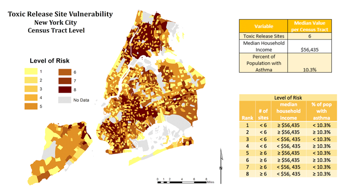
Toxic Release Sites: Vulnerability in New York City
New York City has the largest population in the United States situated upon comparatively small land mass. Within the city are numerous facilities that move, store and/or release pollutants and toxins. The burden of living in close proximity to toxic release sites results in increased exposure to harmful environmental conditions that lead to disproportionate effects on communities that result in overall reduction in quality of life. Studies have shown that socioeconomic vulnerability contributes to increased health disparities which enhances the long-term effects of environmental injustice. US census tract level data, total toxic release inventory sites, household median income and asthma prevalence were examined using Geographic Information Systems to ascertain which residents of New York City bear the highest vulnerability to toxic chemical releases from environmentally undesirable sites.
GIS PresentationProject Methods
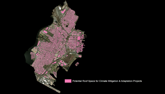
A Spatial Assessment of Roof Space Reutilization Potential In Jersey City
The City of Jersey City is engaging with its constituents to develop a climate action plan outlining city-wide Greenhouse Gas emissions reduction targets and a roadmap of local climate actions. These climate actions call for innovative solutions (reutilizing spaces). This study provides spatial insights of Jersey City rooftop reutilization potential to mitigate and adapt to the climate crisis. The central project inquiries are: What is the total roof space compared to the total land area in Jersey City? What is the total roof space for city-owned buildings compared to other stakeholders? Jersey City’s maximum rooftop reutilization potential is 2.7mi2 which is 16.9% of the municipality’s total land area. Of this maximum roof space potential, the city government owns 0.13 mi2 (5%), residential 1.5 mi2 (56%), private sector 0.62 mi2 (23%), and mixed-use roof space accounts for 0.42 mi2 or 16% of the total roof space in Jersey City.
GIS PresentationProject Methods
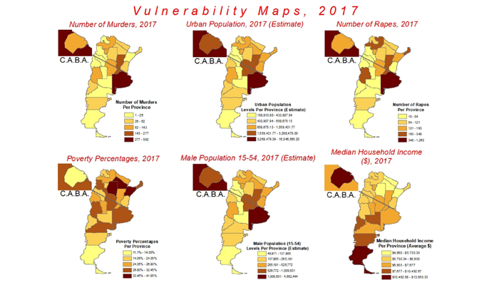
Spatial Analysis of Femicides in Argentina from 2015 to 2019
Femicides are a major social phenomenon - women are killed for their gender. Femicides across the world are significant, yet Latin America commands the most among the top 25 countries with El Salvador and Mexico as leading examples. Argentina, a nation of 45 million, is an unusual case with significant levels of femicides when classed per 100,000 persons. Femicide data per province from 2015 to the first two months of 2019 illustrates trends across this social problem. Moreover, a vulnerability index, incorporating demographic variables such as urban population and poverty, highlight areas with high risk of femicide. This index shows provinces in the north and east are deadlier than other areas around the country. Overall, femicides have been climbing at an alarming rate that warrants serious governmental intervention.
GIS PresentationProject Methods
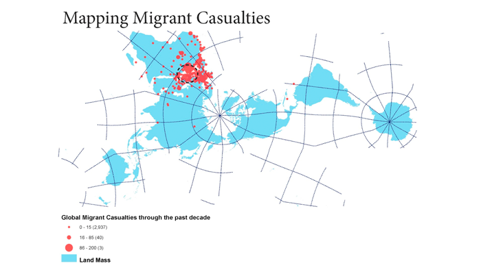
Investigating Migrant Livability
This project attempts to explore the process of migration and geographical challenges faced by the refugees during migration. During the 2015 migration crisis, several travelers lost their lives while migrating through see and their boats sank into the Mediterranean sea. The record of deaths at sea (2,000 approx.) do not only affect the countries of the traveler’s origin, but also the international waters and the laws that apply with in the regional context. A majority of the migrants come from diverse backgrounds having their native languages as Arabic, Urdu and French. While forced migration creates another layer of psychological isolation for the migrants and contributes to the idea of social displacement. Physical displacement is a visually prominent aspect of social displacement but a constant and personal level of social displacement felt by the migrants can be seen through the social isolation of language barriers.
GIS PresentationProject Methods
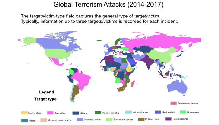
Mapping Global Terrorism
The aim of this project was to visualize through thematic mapping trends in global terrorism. I was interested in mapping major attack type, major weapons used, and target type. China and India are the major countries in Asia that have high in hostage terrorism situations; Africa scored high in hijacking; handgun was prominently used as an armed assault majorly in educational institutes; military was quite prominent in the Middle East; South America and Russia majorly attacked journalists by grenades and sticky bombs; Canada and Australia wasn't high on machinery but was targeted by unarmed assault.
GIS PresentationProject Methods
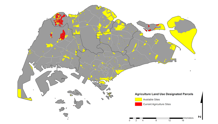
Increasing Food Resiliency in Singapore – Land Suitability Analysis
Even though Singapore is one of the most food secure nations in the world, it is not the most food resilient. Over 90 percent of the country’s food requirements are imported, mostly from the neighboring countries in Southeast Asia, and Australia. One of the options to help Singapore increase its food resiliency is to identify unused parcels of land throughout the city that are suitable for agriculture use. As such, for this study, a GIS spatial framework is used to conduct a survey of agriculture land use in Singapore and a land suitability analysis.
GIS PresentationProject Methods