Student Projects Spring 2018
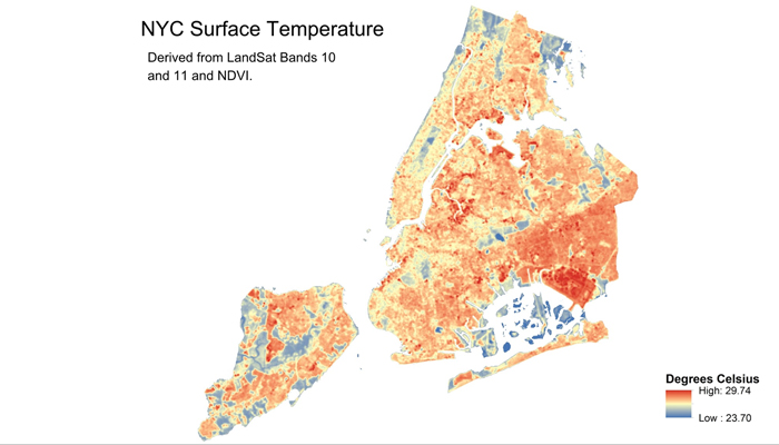
Priority Sites for Increasing Vegetation in New York City
Trees and shrubs filter air pollution, reduce the urban heat island effect, and beautify local neighborhoods. With this in mind, this study analyzed air pollution, surface temperature, and vegetation cover within each district of New York City to determine which ones would benefit most from increasing vegetation in the area. It was found that District 105 had the most concentrated air pollution and the least vegetation, but District 483 had the hottest average temperature. After compiling the top five districts for each category, there was no single district that would benefit most in all three categories. The differences in surface temperature is most likely due to differences in shade around the city, especially near the airports. Further, findings suggest a correlation between air pollution and vegetation cover.
GIS PresentationProject Methods
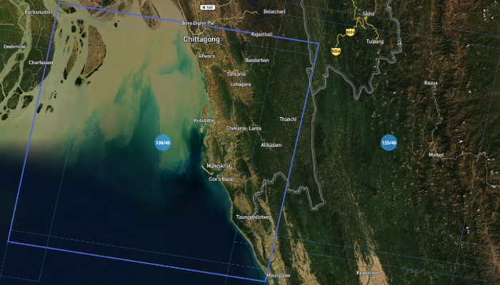
Coastal Erosion and Accretion in Cox’s Bazar, Bangladesh
Utilizing remote sensed imagery, this project addresses coastal changes at Cox’s Bazar, Bangladesh, a popular beach town and fishing port in Bangladesh that is considered a major source of tourism revenue. With an uninterrupted length of 120 kilometers, or 75 miles, the beach in Cox’s Bazar is the longest natural sea beach in the world. Cox’s Bazar also houses the Kutupalong and Nayapara refugee camps, which together hold an estimated population of nearly 800,000 Rohingya refugees fleeing violence and persecution from neighboring Myanmar. This project quantifies coastal erosion and accretion along the shoreline of Cox’s Bazar using Landsat imagery from February 1989 and January 2018.
GIS PresentationProject Methods
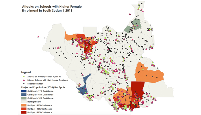
Recent Attacks in South Sudan: Analyzing population density and attacks on hospitals and schools
This project addresses the spatial distribution of acts of violence committed in South Sudan on hospitals and schools with both female school-age enrollment as well as population density estimates. This analysis also serves to support findings of the Watchlist on Children and Armed Conflict Practicum (PIA) project, as well as to investigate some of the social costs of the violence that plagues the world’s newest country. After isolating those events that overlap with hospitals, clinics, and schools, the findings of the map analysis reinforce the trend that attacks on these facilities do exist in higher, or more densely populated areas of the country.
GIS PresentationProject Methods
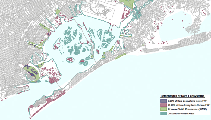
Preservation Status of Rare Ecosystems in Jamaica Bay, New York
Jamaica Bay, New York, possessing rare ecosystems, continues to face salt marsh degradation. This project assesses preserve areas and remaining habitat core areas suitable for preservation status. Specifically, protected status allocated to rare ecosystems that fall within the boundaries of the Nature Conservancy’s Conservation Priority Areas is assessed. Approximately 57% of the area covered by rare ecosystems identified in the US fall within the boundaries of the Nature Conservancy’s Conservation Priority areas, whereas only 28% of rare ecosystems in the US are currently held in protected status (EnviroAtlas 2015). Using overlay analysis, this project identifies rare ecosystems within the priority areas.
GIS PresentationProject Methods
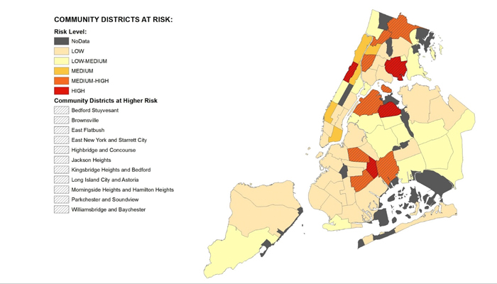
New York City community districts at risk: a HIV and health facilities spatial analysis
According to the HIV Surveillance Annual Report of 2016 for New York City, there were 2279 people newly diagnosed with HIV and 87,700 people living with HIV in NYC in 2016. Access to health services and facilities can play a determinant role in the decrease/increase of transmission risk of HIV. This project utilizes NYC community districts as a unit of analysis for determining both risk rates and service coverage.
GIS PresentationProject Methods
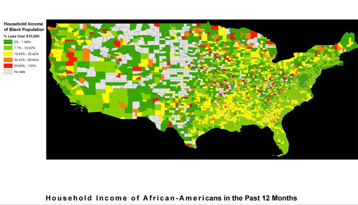
Mapping the Racial Wealth Divide in the United States
This thematic mapping study seeks to illustrate the international right to reparations for African descendants in the United States by focusing on income/ wealth inequality and housing discrimination. Reparations is a political act of recognition that acknowledges African descendants who have been systematically silenced and barred from their political and human rights. Moreover, reparations are a form of justice and socioeconomic development for black people who have been excluded from the integral intergenerational wealth transfer which defines economic prosperity in the U.S. This project visually and geographically explores specific historically determined wealth issues in the black community. Resulting maps illustrate the urgency of legislative measures for the U.S. to take before the end of the International Decade for People of African Descent in 2024.
GIS PresentationProject Methods