Student Projects Spring 2024
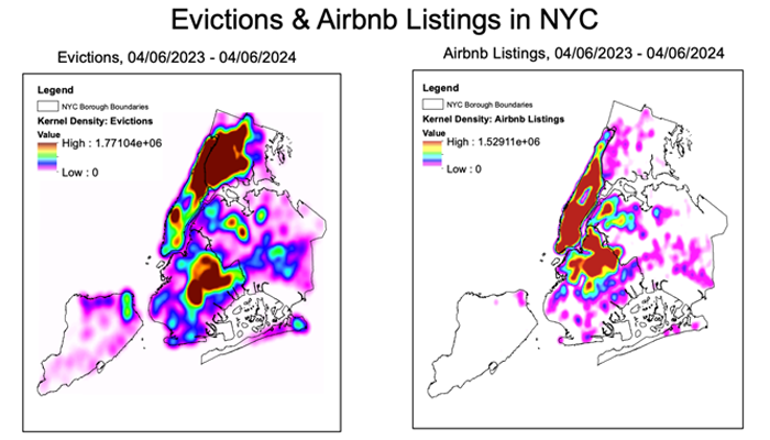
Oskar Roberts-Grmela | Airbnb Listings & Evictions in New York City
Over the past decade, the number of Airbnb rentals in New York City has surged exponentially. Recently, housing justice activists, local community groups, and some politicians have rallied against Airbnb based on the premise that the short term rental market contributes to displacement and gentrification. However, the relationship between Airbnb and displacement remains under-researched. In order to gain insight into this relationship, I conducted a GIS analysis of Airbnb and eviction data. Using publicly available data from Inside Airbnb and NYC Open Data, I mapped the locations of Airbnb listings and evictions in New York City from 04/06/2023 through 04/06/2024. Then I analyzed the spatial density of each data set and assessed the correlation between rates of eviction and Airbnb rentals.
GIS PresentationProject Methods
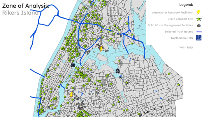
Onyx Oliveira | Renewables on Rikers Island: MTS for DSNY
This project integrates insights from my undergraduate thesis into a cartographic exploration of New York City's waste management challenges and opportunities. Focusing on the closure of Rikers Island, the map assesses its potential as a centralized waste processing facility, aligning with the Renewable Rikers Act and addressing critical issues in urban waste management. I collected and analyzed data from various sources, including the Department of Sanitation of New York (DSNY) open database, the Mayor’s Office of Climate and Environmental Justice, ArcGIS Online, and the EJNYC 2024 report and interactive map. This approach allowed me to map current waste facilities, transportation routes, and environmental justice areas, providing a holistic view of NYC's current waste infrastructure. The project's primary objective was to evaluate how repurposing Rikers Island could benefit the Department of Sanitation and improve waste management efficiency citywide. By simulating different waste processing scenarios and considering spatial constraints, the map offers insights into potential operational efficiencies, reduced emissions, and economic benefits associated with centralizing waste processing on Rikers Island. Rikers Island's geography, history, and limited land use potential make it an ideal incubator for testing innovative resource capture methods as waste processing and sorting technologies advance.
GIS PresentationProject Methods