Student Projects Spring 2024
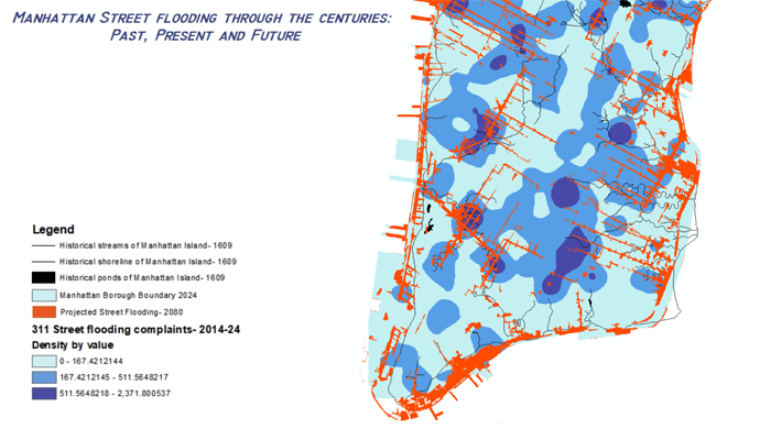
Ananya Agarwal | NYC Flooding: a city's past and present predicts its future
Street flooding is an escalating issue in New York City, causing significant disruptions and posing risks to infrastructure and public safety. This study investigates the historical, present, and projected future street flooding on Manhattan Island to understand its ecological impact and inform future urban resilience strategies. By utilizing historical data from the Welikia Project, current 311 flood complaints, and future flood projections from the NYC Stormwater Flood Map, this research provides a comprehensive analysis of flooding patterns. The methodology involved overlaying Manhattan's historical shorelines and water bodies with present-day 311 flood complaints and future street flooding predictions. My results indicate a strong correlation between present flood complaints and projected future flood zones, revealing that areas prone to flooding today often coincide with historical water bodies and are likely to experience increased flooding in the future. This highlights the need for improved infrastructure and proactive planning to mitigate future flood risks, drawing from historical insights to address contemporary challenges.
GIS PresentationProject Methods
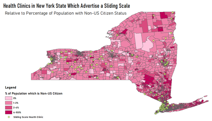
Ada Shookenhuff | Health Clinics in NY State Which Advertise Sliding Scale
I produced this map to approach an issue of data organization that has presented itself to me over the last year. New York State has a rising immigrant population, which means a rising demand for social and health needs. I’ve witnessed the value of clinics which offer a sliding scale program as they have helped non-US citizens in my life afford essential medical procedures. For this reason I aimed to create a map to highlight the proximity of clinics which are, in theory, affordable, to populations that are most in need of them. The challenge is that there is no centralized list of clinics which offer this, and there seems to be somewhat of a gray area when it comes to finding a clinic near you that you can afford.
GIS PresentationProject Methods

Christian D'Ostilio | Mortgage Denials, Race, New York City Census Tracts
With the creation of the HMDA Act of 1975, all financial institutions became required to disclose extensive data on their lending records. Crucial information such as race, familial status, loan amount, location, and approval status provides essential implications for greater focus on targeting socio-economic resources and accountability. I explored the connection between race and mortgage rate denials per census tract in NYC. I intended to identify where there were high concentrations of mortgage denial rates and what socio-economic factors, such as race, made up the areas. I hypothesized that there would be a clear correlation between higher rates of mortgage denial rates in low-income communities of color. After conducting my investigation, I found that this hypothesis needs to be more conclusive. The data ranged greatly with multiple concentrations of denial rates in more affluent, whiter areas compared to concentrated denial rates in lower-income areas of color. While the correlation is in conclusion, this exploration led to important further considerations in the next steps into a deeper investigation of access to homeownership and socio-economic variables.
GIS PresentationProject Methods
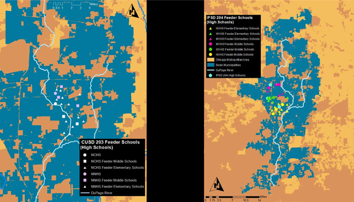
Eric Bonner | Seeing the Suburbs Through Schools
In the 21st century, the Earth is experiencing significant change. Extreme weather events stemming from climate change and large scale urbanization are altering the ways that billions of people live. In the United States, Cities are taking on the challenge of climate change adaptation. While concentrating on cities is important, the suburbs are now where a majority of Americans call home. Despite holding a large share of the population, there are over 3,000 suburban or small cities, while there are only ten cities that exceed a population of one million. Creating individualized strategies for municipalities is a task that will require significant energy and expertise. Manual for the DuPage River Basin proposes that by grouping suburban municipalities together using agglomerative hierarchical clustering in union with local knowledge, naturalistic inquiry, landscape and geospatial analysis, that plans can be drafted and scaled beyond municipal boundaries to relevant communities in a more effective manner.
GIS PresentationProject Methods
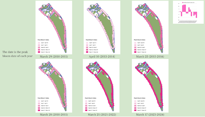
Noah Handfield | Mapping Cherry Blossom Blooms
For my GIS final project I am going to map how the blooming season of cherry blossoms in Washington DC is getting earlier due to climate change. This project is related to my thesis project which is about using nature’s healing properties for treating mental health. I want to show the relationship between climate, geography, and ecology. These maps can help identify how the peak bloom date has changed even in the past decade, to warn about this trend continuing in the future. The organizations that can be connected to this project are the National Park Service and the Environmental Protection Agency (EPA). My capstone project for my studio right now is incorporating gardening and farming, so this connects to something I’m currently working on. I plan to show maps illustrating the peak bloom date over the past decade in Washington DC.
GIS PresentationProject Methods
Katina Chang | LEED Buildings and the Local Environment
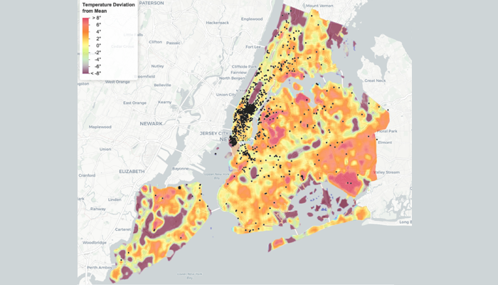
This project investigates the correlation between the locations of LEED-certified buildings and local microclimates, specifically focusing on temperature variations and air quality across New York City. The central theme is urban analysis and design, emphasizing the impact of sustainable buildings on their immediate environments in densely populated urban settings. As climate change prompts a global shift towards sustainable construction, understanding the local environmental benefits of these buildings is crucial but often overlooked.
- Using Geographic Information Systems (GIS), this research will map LEED-certified buildings in NYC alongside data on local temperature variations and air quality—specifically black carbon, fine particles (PM 2.5), and nitric oxide (NO). This spatial analysis will reveal patterns and correlations that can inform sustainable urban development practices. Relevant organizations include LEED which promotes green building standards, and government bodies that monitor environmental data.
- This inquiry stems from my experience as an architectural design major, where sustainable practices are often discussed in theory but not thoroughly examined for their local environmental impact. This project aims to bridge that gap, contributing to a more holistic understanding of sustainable urban design.
Project Methods